
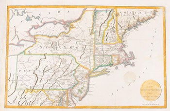
Map of the Northern Provinces of the United States. First Edition.
London: R. Phillips, 1804. Engraved map, hand-colored (likely later). 32.6x51.1 cm (12¾ x 20").
Tooleys Dictionary of Mapmakers , vol. 3, p. 426 (Richard Phillips 1767-1840) & vol. 4, p. 87 (Russell, Jr.)
Phillips, Maps of North America , p. 873
Scarce.
Map of all of the Northeast and Mid-Atlantic, extending south to below Alexandria and west to beyond Wheeling on the Ohio River. Early county development in Pennsylvania is current to 1794, prior to the organization of Greene and Lycoming Counties. The Lands of the Six Nations appear in western New York beside Lake Erie. There is very good detail of roads throughout the region. The map is from John Marshall's Life of Washington. Engraved by John Russell Jr.
Condition: Left margin extended with tissue curing some raggedness, 1½" circular stain in Atlantic Ocean; old folds; very good. Item #16-3572
Price: $700.00