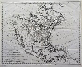
Karte von Nord-America zur Geschichte von Neu-frankreich. Early edition of the map.
Leipzig: 1755. Original engraved map on laid paper with various watermarks. 31 x 36 cm. Leipzig ed. of Bellin's map of North America, 1st published in 1743. From Charlevoix's "Histoire et description générale de la Nouvelle France". One of Bellin's earliest maps of any part of North America, rich with Indian information, notes, early French forts and other early features...
Barry Ruderman:
The most distinctive feature of this map is the definitive and highly direct water route from Lake Superior to the Pacific Ocean. While Bellin was somewhat tentative in his treatment of the NW Coast of America, this straight wide-open water course though the Lake of the Woods and Lake Winnipeg is a remarkable feature. The areas explored by D'Aguilar and D'Font on the west coast of North America are very much in evidence, as are the results of the Jesuit Missionaries travels in the Great Lakes and Upper Mississippi Valley.
The map is one of Bellin's earliest maps of any part of North America.. The map was produced for Charlevoix's Histoire et description générale de la Nouvelle France. The map was compiled in part from the Chaussegros de Lery manuscripts and is also noteworthy for the fictious mountain range in Michigan. Rich with Indian information, notes, early french forts and other early features.
In 1720 the Duke of Orleans sent the Jesuit scholar and explorer Pierre François-Xavier de Charlevoix to America to record events in New France and Louisiana and determine the best route to the Pacific Ocean. Charlevoix gathered geographic information from fur traders in Quebec and traveled through the Great Lakes and down the Mississippi River. After he returned to France, Charlevoix published his views on North America in his Histoire et description générale de la Nouvelle France, which has become one of the most important works on North America during the period prior to the French & Indian (Seven Years) War.
Thomas Jefferson owned a copy of Charlevoix's Histoire et description générale and recommended it, along with the accounts of Hennepin and Lahontan, as a "particularly useful species of reading." He referred to Charlevoix's book as he developed his own ideas of Louisiana and the Northwest. Item #16-4016
Price: $450.00