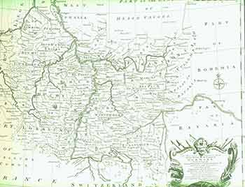
A New and Correct Map of the South West part of Germany, Containing the Archbishopricks and Electorates of Mentz and Triers. (18th Century Map of Germany).
[London]: 18th Century European Publisher, [1700s]. 20 x 16 inches. Very Good. Minor loss from pinholes in top right corner. Fine copperplate engraving. 18th Century, uncolored, folded map of Germany. Scarce. Item #18-0865
Price: $150.00
See all items in
Ephemera
See all items by Eman Bowen, engraver