
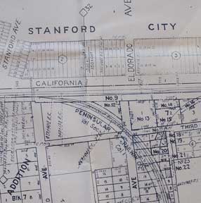
Right of Way and Track Map, Palo Alto, Main Line Mayfield, Santa Clara County, California.
San Francisco, Calif.: Southern Pacific Company, 1938. Map. Blueline print. 24 x 56 inches. With red and orange pencilling. Map of Mayfield, from Churchill Avenue to Diss Road. Includes Sunnyside and Evergreen Park. With Schedule of Property Acquisition (Date, Original Grantor/Grantee, Instrument of Transfer, and Remarks of Sale) for approximately 26 transfers, 1864-1938. Scale 1 inch = 200 feet. Item #56-0222
Price: $350.00
See all items in
Ephemera
See all items by Southern Pacific Lines, Calif San Francisco