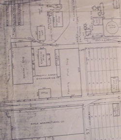
Plan of Alameda Park - Blanding. California. Map.
San Francisco, Calif.: Southern Pacific Company, 1931, revised 1940. Map. Blueline print. 24 x 56 inches. Map of Alameda from west of Oak Street to High Street. Includes Boyle Manufacturing Co, Pacific Coast Engineering Co, all streets. Scale: 1 inch = 100 feet. Item #56-0232
Price: $350.00
See all items in
Ephemera
See all items by Southern Pacific Lines, Calif San Francisco