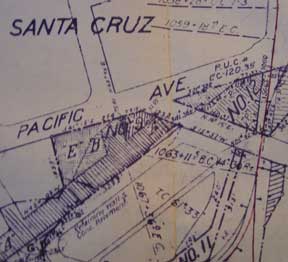
Right of Way and Track Map, Watsonville Junction to Olympia, Santa Cruz County, California.
San Francisco, Calif.: Southern Pacific Company, [n.d.]. Map. Blueline print 24" x 55" with red pencil indicating switching limits. Includes Santa Cruz and station point Eblis. From San Lorenzo, Cottonwood St and River St to the north, to Bay of Monterey and Santa Cruz St to the south. Scale 1" = 200'. Item #56-0302
Price: $350.00
See all items in
Ephemera
See all items by Southern Pacific Lines, Calif San Francisco