
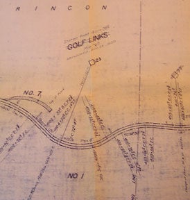
Right of Way and Track Map, Watsonville Junction to Olympia, Santa Cruz County, California.
San Francisco, Calif.: Southern Pacific Company, 1937. Map. Blueline print 24" x 55" with red pencil indicating switching limits. Includes Rancho de la Canada de Rincon, discontinued station point Golf Links. From approx 4000' northwest of Golf Links, to Coral St to the south-east. With schedule of Property listing appox 10 transfers, 1875-1937. Scale 1" = 200'. Item #56-0304
Price: $350.00
See all items in
Ephemera
See all items by Southern Pacific Lines, Calif San Francisco