Industrial Map of Portland, Oregon.
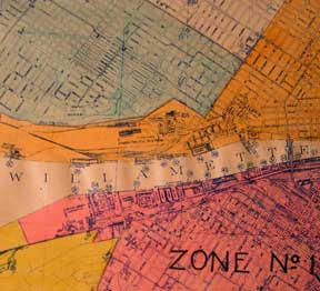
Portland, Ore.: Commission of Public Docks, 1924. Map. Blueline print, 23" x 49" with multicolor shading indicating switching zones. From meeting of Williamette and Colombia to eastern city boundary, Linnton District to Vancouver, Washington. With index to Port facilities, approx 75 listings of docks, shipping industries, and misc. industries using Harbor frontage. Scale approx 1" = 1700'. Item #56-0365
Price: $425.00
See all items in
Ephemera
See all items by Southern Pacific Lines, Calif San Francisco