
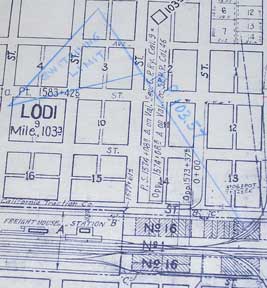
Right of Way and Track Map of Lodi, San Joaquin County, CA
San Francisco, Calif.: Southern Pacific Company, 1945. Blueline print, 24" x 55". Sheet one of three. Switching limits indicated in colored pencil. From Cherokee Lane to Grant Street, with approx 1 1/2 miles north and 2 miles south of station point Lodi. Includes Lodi Barnhart Tract. With Schedule of Property listing approx 110 transfers, 1868 - 1945. Scale 1" = 400'. Item #56-0458
Price: $350.00
See all items in
Ephemera
See all items by Southern Pacific Lines, Calif San Francisco