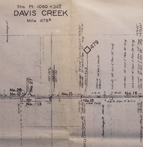
Right of Way and Track Map of Davis Creek, Garret, Alturas, Modoc County, CA.
San Francisco, Calif.: Southern Pacific Company, 1952. Blueline print, 24 inches x 55 inches. From approx 5 miles south of Station Point Davis Creek to approx 2 miles north of abandoned Station Point Garret. No structures indicated, extensive listing of signal and track measurements. With Schedule of Property listing approx 30 transfers, 1875-1952. Scale 1 inch = 1000 feet. Item #58-0546
Price: $350.00
See all items in
Ephemera
See all items by Southern Pacific Lines, Calif San Francisco