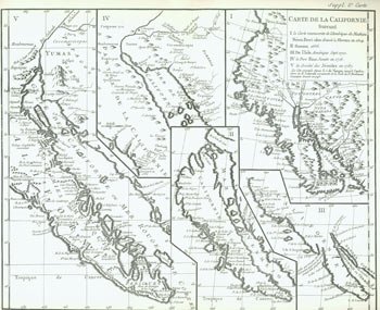
A Map of California. Showing Its Delineation at Various Periods. With an Explanation Compiled from Various Sources.
[Berkeley, CA: Howell-North Press], 1966. Folio, [4 pp.] String-Bound Wraps. Very Good, slight crease. Folded Maps. "Printed in an edition of 125 copies for Michael Harrison, Lester Lloyd, David Magee, and Duncan H. Olmsted to present to their friends in the Zamorano Club of Los Angeles and the Roxburghe Club of San Francisco on the occasion of the joint meeting of the two clubs in Los Angeles, September 24th and 25th, 1966 ... Also 100 copies were printed for Duncan Olmsted to present to members of the Petaluma Historical Society and other friends at Christmas, 1966." Item #63-2087
Price: $50.00
See all items in
Books
See all items by Duncan H. Olmsted, Didier Robert de Vaugondy