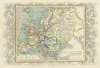
Europe (18th Century Map of Rome).
[London]: 18th Century European Publisher, [1700s?]. 8 x 11 inches. Very Good. 18th Century colored map, with hand drawn borders. Scarce. More
[London]: 18th Century European Publisher, [1700s?]. 8 x 11 inches. Very Good. 18th Century colored map, with hand drawn borders. Scarce. More

Gotha, Germany: Justus Perthes Geographische Anstalt, [1850]. 14 x 17 inches. Very Good. Minor foxing on edges of margins, not affecting image. 19th Century folded map, printed in color, with hand colored borders. From Stieler's Hand-Atlas (No. 19). Text in German. Scarce. Johann Georg Justus Perthes (11 September 1749, Rudolstadt..... More
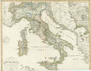
Gotha, Germany: Justus Perthes Geographische Anstalt, [1844]. 14 x 17 inches. Very Good. 19th Century folded map, printed in color, with hand colored borders. From Stieler's Hand-Atlas (No. 32). Text in German. Scarce. Johann Georg Justus Perthes (11 September 1749, Rudolstadt, Schwarzburg-Rudolstadt – 2 May 1816, Gotha, Saxe-Gotha-Altenburg) was a...... More
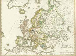
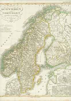
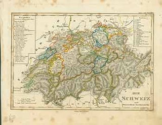
Gotha, Germany: Justus Perthes Geographische Anstalt, [1848]. 14 x 17 inches. Very Good. Some foxing in margins, not affecting image. 19th Century folded map, printed in color, with hand colored borders. From Stieler's Hand-Atlas (No. 12). Text in German. Scarce. Johann Georg Justus Perthes (11 September 1749, Rudolstadt, Schwarzburg-Rudolstadt –..... More
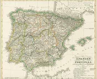
Gotha, Germany: Justus Perthes Geographische Anstalt, [1850]. 14 x 17 inches. Very Good. 19th Century folded map, printed in color, with hand colored borders. From Stieler's Hand-Atlas (No. 14a). Text in German. Scarce. Johann Georg Justus Perthes (11 September 1749, Rudolstadt, Schwarzburg-Rudolstadt – 2 May 1816, Gotha, Saxe-Gotha-Altenburg) was a...... More
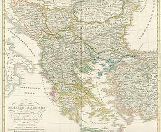
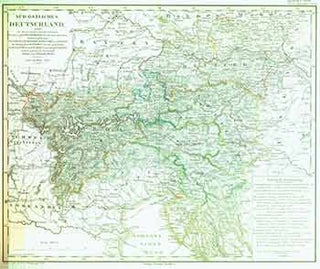
Gotha, Germany: Justus Perthes Geographische Anstalt, [1850s?]. 14 x 17 inches. Very Good. 19th Century folded map, printed in color, with hand colored borders. From Stieler's Hand-Atlas (No. 38c). Text in German. Scarce. Johann Georg Justus Perthes (11 September 1749, Rudolstadt, Schwarzburg-Rudolstadt – 2 May 1816, Gotha, Saxe-Gotha-Altenburg) was a...... More
Gotha, Germany: Justus Perthes Geographische Anstalt, [1850s?]. 14 x 17 inches. Very Good. Some foxing in margins, not affecting image. 19th Century folded map, printed in color, with hand colored borders. From Stieler's Hand-Atlas (No. 33.). Text in German. Scarce. Johann Georg Justus Perthes (11 September 1749, Rudolstadt, Schwarzburg-Rudolstadt –..... More
Gotha, Germany: Justus Perthes Geographische Anstalt, [1850s?]. 14 x 17 inches. Very Good. Some foxing in margins, not affecting image. 19th Century folded map, printed in color, with hand colored borders. From Stieler's Hand-Atlas (No. 38). Text in German. Scarce. Johann Georg Justus Perthes (11 September 1749, Rudolstadt, Schwarzburg-Rudolstadt –..... More
Gotha, Germany: Justus Perthes Geographische Anstalt, [1850]. 14 x 17 inches. Very Good. Minor foxing on edges of margins, not affecting image. 19th Century folded map, printed in color, with hand colored borders. From Stieler's Hand-Atlas (No. 17). Text in German. Scarce. Johann Georg Justus Perthes (11 September 1749, Rudolstadt..... More
Gotha, Germany: Justus Perthes Geographische Anstalt, [1850]. 14 x 17 inches. Very Good. 19th Century folded map, printed in color, with hand colored borders. From Stieler's Hand-Atlas (No. 13). Text in German. Scarce. Johann Georg Justus Perthes (11 September 1749, Rudolstadt, Schwarzburg-Rudolstadt – 2 May 1816, Gotha, Saxe-Gotha-Altenburg) was a...... More
Gotha, Germany: Justus Perthes Geographische Anstalt, [1850]. 14 x 17 inches. Very Good. 19th Century folded map, printed in color, with hand colored borders. From Stieler's Hand-Atlas (No. 25). Text in German. Scarce. Johann Georg Justus Perthes (11 September 1749, Rudolstadt, Schwarzburg-Rudolstadt – 2 May 1816, Gotha, Saxe-Gotha-Altenburg) was a...... More
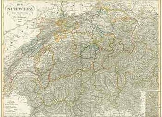
1856. Large map measuring 71 x 107 cm. (28 x 42 inches). Scale = 1:50,000. Mounted on canvas. Very attractive. More
Torino: Fratelli Pozzo, [ca. 1920]. Railroad map for Italy, the Colony of Eritrea, and major European cities. Color photolithograph. 20 x 25-1/4 inches. Shows major railroad routes for italy, Sicily, Sardinia, Corsica and parts of Serbia (then Dalmatia) and Montenegro on one side. The reverse shows main European rail lines..... More
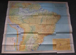
Brasil: Fundação IBGE, Instituto Brasileiro de Geografia, 1972. Color map measuring 45 x 38 inches. Scale = 1:5,000,000. Folded, with several tears along folds. More
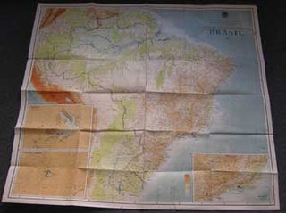
Brasil: Fundação IBGE, Instituto Brasileiro de Geografia, 1965. Color map measuring 45 x 38 inches. Scale = 1:5,000,000. Folded, with several tears along folds. More
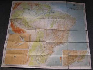
Brasil: Fundação IBGE, Instituto Brasileiro de Geografia, 1965. Color map measuring 45 x 38 inches. Scale = 1:5,000,000. Folded, with numerous tears along folds and edge. More
Williamsburg, Va.: Colonial Williamsburg Foundation, ca. 1960s. Folded color map measuring 18 x 24 inches, with index to buildings and sites of interest. Very good, suitable for framing. More
London: Gentleman's Magazine, [1739]. 14 x 12 inches. Very Good. 18th Century, folded map. Scarce. More
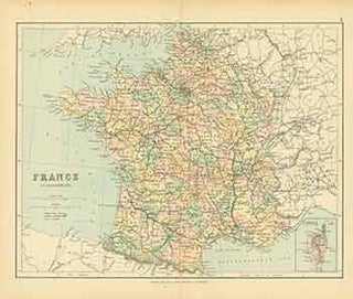
London: George Philip & Son, [1870s - 1880s?]. 11 x 13 inches. Very Good. Minor half inch tear at bottom along fold, and another half inch tear at bottom edge. Folded map of France. More
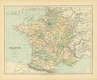
London: George Philip & Son, [1870s - 1880s?]. 11 x 13 inches. Very Good. Folded map of France in Provinces. More
Germany: Justus Perthes, [1870s - 1880s?]. 9 x 12 inches. Very Good. Some foxing from age. Hand-colored map of Germany. Text in German. More
London: 1753. Engraved cartouche only. 16 x 10.5 cm. A prolific 18th century engraver of maps, including the rare Maps of the Chief Roads in England, showing the various Routes from London - 1765, smaller format county maps included. His best known work is the New and Accurate Maps of..... More
[Rome], Italy: Giuseppe, 1706. Copperplate engraving. Laid Paper. 14" x 12". Very Good with repair on verso. Text in Latin. More
[Philadelphia, Pa.: The Port Folio, 1810]. Line etching measuring 11 x 9 inches. The map had accompanied an article by Thomas Cooper entitled "A Ride to Niagara." In the arcticle, Cooper writes of "M'Alpin's map of the turnpike roads of New York state." The map shows from the state as..... More
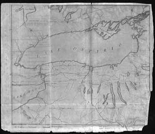
[Philadelphia, Pa.: The Port Folio, 1810]. Line etching measuring 11 x 9 inches. The map had accompanied an article by Thomas Cooper entitled "A Ride to Niagara." In the arcticle, Cooper writes of "M'Alpin's map of the turnpike roads of New York state." The map shows from the state as..... More