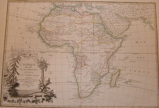
L'Afrique Divisee En Ses Principaux Etats.
Paris, France: Janvier, 1782. Engraving. Watermarked Laid Paper. 15" x 20.5". Good with a few small tears at edges, minor creasing. Text En Francais. More
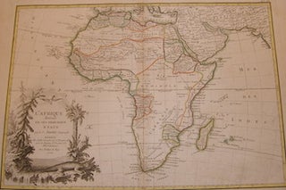
Paris, France: Janvier, 1782. Engraving. Watermarked Laid Paper. 15" x 20.5". Good with a few small tears at edges, minor creasing. Text En Francais. More
Paris, France: Janvier, 1762. Engraving. Laid Paper. 20.25" x 15.25". Good with tears. En Francais. More
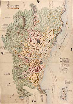
Japan: 19th Century. Manuscript map of Sakata and Tsuruoka on the coast of northern Japan, indicating the sea routes to Akita, to the north, and Niigata, to the south, Mount Gassan shown to the south-east, and Mount Chokai to the north, a color key to the the various affiliations of..... More
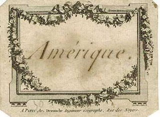
Paris: Dezauche, [1802]. Engraved cartouche only. 8 x 10 cm. Library of Congress Control Number 98685633 Éditeur et marchand de cartes géographiques ; graveur ; ingénieur géographe. - Établi vers 1770 après avoir, semble-t-il, gravé de la musique dès 1762. Rachète en juin 1780 le fonds géographique de Guillaume Delisle..... More
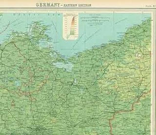
Edingurgh: The Edinburgh Geographical Institute, [1922?]. 23 x 18 inches. Very Good. Folded color map. Index printed on reverse. Scarce. More
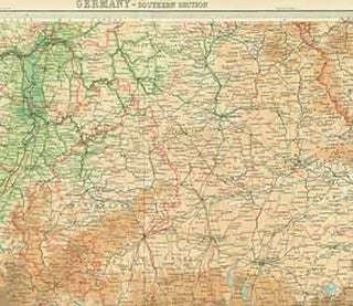
Edingurgh: The Edinburgh Geographical Institute, [1922?]. 23 x 18 inches. Very Good. Folded color map. Index printed on reverse. Scarce. More
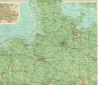
Edingurgh: The Edinburgh Geographical Institute, [1922?]. 23 x 18 inches. Very Good. Folded color map. Index printed on reverse. Scarce. More
![Item #15-8951 North America. [Map]. John Betts, London](https://art-books.cdn.bibliopolis.com/pictures/15-8951.jpg?width=320&height=427&fit=bounds&auto=webp&v=1443196264)
London: John Betts, [1830]. 32 x 37 cm. Incomplete Map, Hand-colored, Dissected and Mounted on Linen. Relief Show by Hachures. Includes Inset of Jamaica. Five out of nine squares missing. Fair with some creasing. More
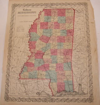
New York, NY: Johnson & Browning, 1859. Printed Color Map. 13.5" x 17" Good with tears and minor losses along edges. More
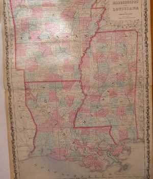
New York, NY: Johnson & Ward, 1862. Printed Color Map. 26.5" x 17.75" Folded.Good with tears, minor staining, and minor losses along edges. More
Gotha, Germany: Justus Perthes Geographische Anstalt, [1850]. 14 x 17 inches. Very Good. One inch tear in bottom margin along fold, not affecting image. 19th Century folded map, printed in color, with hand colored borders. From Stieler's Hand-Atlas (No. 10). Text in German. Scarce. Johann Georg Justus Perthes (11 September..... More
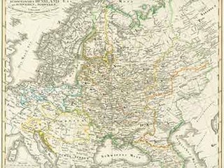
Gotha, Germany: Justus Perthes Geographische Anstalt, [1850]. 14 x 17 inches. Very Good. 19th Century folded map, printed in color, with hand colored borders. From Stieler's Hand-Atlas (No. 37a). Text in German. Scarce. Johann Georg Justus Perthes (11 September 1749, Rudolstadt, Schwarzburg-Rudolstadt – 2 May 1816, Gotha, Saxe-Gotha-Altenburg) was a...... More

Gotha, Germany: Justus Perthes Geographische Anstalt, [1850s?]. 14 x 17 inches. Very Good. Half inch tear in bottom margin, not affecting image. 19th Century folded map, printed in color, with hand colored borders. From Stieler's Hand-Atlas (No. 35). Text in German. Scarce. Johann Georg Justus Perthes (11 September 1749, Rudolstadt..... More
Gotha, Germany: Justus Perthes Geographische Anstalt, [1850]. 14 x 17 inches. Very Good. 19th Century folded map, printed in color, with hand colored borders. From Stieler's Hand-Atlas (No. 21). Text in German. Scarce. Johann Georg Justus Perthes (11 September 1749, Rudolstadt, Schwarzburg-Rudolstadt – 2 May 1816, Gotha, Saxe-Gotha-Altenburg) was a...... More
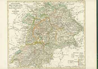
Gotha, Germany: Justus Perthes Geographische Anstalt, [1850s?]. 14 x 17 inches. Very Good. Half inch tear in bottom margin, not affecting image. 19th Century folded map, printed in color, with hand colored borders. From Stieler's Hand-Atlas (No. 24). Text in German. Scarce. Johann Georg Justus Perthes (11 September 1749, Rudolstadt..... More
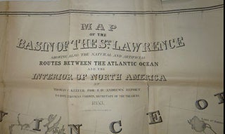
Washington, DC: 1853. Handcolored lithograph. Some clean tears along the many folds. hand colored ; 88 x 195 cm., folded to 23 x 15 cm. Appears in: Andrew's Communication from the Secretary of the Treasury: Report of Israel D. Andrews on the trade and commerce of the British North American..... More
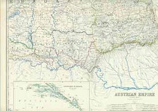
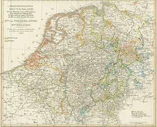
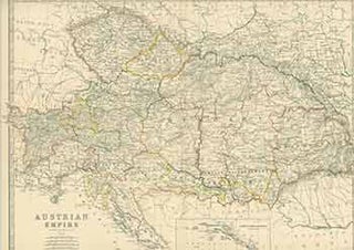
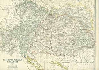
Edinburgh: William Blackwood & Sons, [1851]. 24 x 19 inches. Very Good. Half inch tear in right margin along fold. 19th Century folded map, printed in color, with hand colored borders. Inset of Continuation of Dalmatia. From Keith Johnston’s General Atlas. More
Edinburgh: William Blackwood & Sons, [1800s]. 14 x 18 inches. Very Good. Half inch tear in bottom margin along fold. 19th Century, folded map, printed in color. More
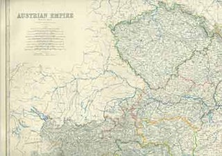
Edinburgh: William Blackwood & Sons, [1851]. 24 x 19 inches. Very Good. One inch tear in right margin along fold. 19th Century folded map, printed in color, with hand colored borders. Inset of Vienna (Wien) and its environs. More
Edinburgh: W. & A. K. Johnston, [1800s]. 14 x 18 inches. Very Good. 19th Century, folded map, printed in color. More
Edinburgh: W. & A. K. Johnston, [1800s]. 18 x 15 inches. Very Good. 19th Century, folded map, printed in color. Scarce. More
Edinburgh: William Blackwood & Sons, [1800s]. 14 x 18 inches. Very Good. Half inch tears in left and right margins along fold. 19th Century, folded map, printed in color. More
Edinburgh: W. & A. K. Johnston, [1800s]. 14 x 18 inches. Very Good+. 19th Century, folded map, printed in color. More
Edinburgh: W. & A. K. Johnston, [1800s]. 14 x 18 inches. Very Good. 19th Century, folded map, printed in color. More
Edinburgh: William Blackwood & Sons, [1800s]. 14 x 18 inches. Very Good. 4 inch tear along fold at bottom, has been repaired. 19th Century, folded map, printed in color. More