
Rue de la Grosse-Horloge. Rouen.
Paris, France: Fisher, Son & Co., [mid 19th century]. 20.5 x 26.5 cm. Good. Some foxing and darkening along edges; clipping on right edge. Engraving. Text in French and German. More
Paris, France: Fisher, Son & Co., [mid 19th century]. 20.5 x 26.5 cm. Good. Some foxing and darkening along edges; clipping on right edge. Engraving. Text in French and German. More
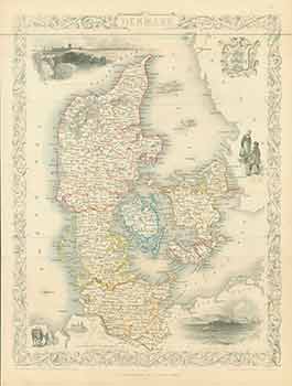
London: London Printing And Publishing Company, [1860s - 1890s?]. 11 x 14 inches. Very Good. Minor foxing. Folded, hand-colored map of Denmark. More
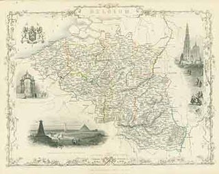
London: John Tallis & Company, [1860s - 1890s?]. 11 x 14 inches. Very Good. Folded, hand-colored map of Belgium. More
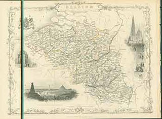
London: London Printing And Publishing Company, [1860s - 1890s?]. 11 x 14 inches. Very Good. Folded, hand-colored map of Belgium. More

NY, NY: J. & F. Tallis, 1851. 27 x 36 cm. [4 pp.] Good. Printed in B&W on wove rag. Small binding holes along left edge. Toning along sheet edges. [Withdrawn from book: The Illustrated Atlas, And Modern History Of The World Geographical, Political, Commercial & Statistical]. More

NY, NY: J. & F. Tallis, 1851. Map 27 x 37 cm. Good. Printed in B&W with hand-drawn Color ink on wove rag. Small binding holes along left edge. Toning along sheet edges. Illustrations by H. Warren, engraved by J.B. Allen; Map drawn and engraved by J. Rapkin Scale: 1..... More

NY, NY: J. & F. Tallis, 1851. Map 27 x 36 cm. Good. Printed in B&W with hand-drawn Color ink on wove rag. Small binding holes along left edge. Toning along sheet edges. Small vertical blade incision with small tear in center (under the space between "Jebel" and "Ajlun") Illustrations..... More

