
Industry Map of Stockton and Vicinity, Fresno County, California.
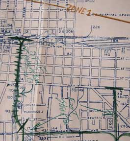
San Francisco, Calif.: Southern Pacific Company, 1950, revised 1959. Map. Blueline print, 28" x 49", with extensive brown, red, blue, orange and green pencilling indicating zones, and yard limits. From French Camp to Calaveras River, and San Joaquin River to US 99/Manteca Road. Includes Index to Industries wiith approx 250 listings. Scale 1" = 800'. with insert showing Rough and Ready Island, scale 1" = 2000'. Item #56-0332
Price: $425.00
See all items in
Ephemera
See all items by Southern Pacific Lines, Calif San Francisco